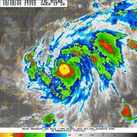
 At 8pm EST this evening Wilma has strengthened to a Category 2 hurricane with 100mph winds and a central pressure of 954mb. That is a significant pressure drop over a 24 hour period (35mb). Wilma is now entering a period of rapid intensification and there really is no limit to how strong she could get over the next 36 hours. The small eyewall is clearly visible on infrared satellite images. Winds could reach in excess of 115mph by 5am tomorrow morning as the circulation catches up with the sharp drop in pressure. SST's are 88-90 degrees in the NW Caribbean Sea, high grade fuel for this hurricane. Recent model runs have picked up the speed of Wilma over the next 96 hours, which means the Southwest Florida coast could be dealing with a major hurricane by Saturday. Residents in these coastal areas should be in the process of executing their emergency plans with a goal of being off the coast by Thursday. This is quickly becoming a very dangerous situation for South Florida.
SCM


No comments:
Post a Comment