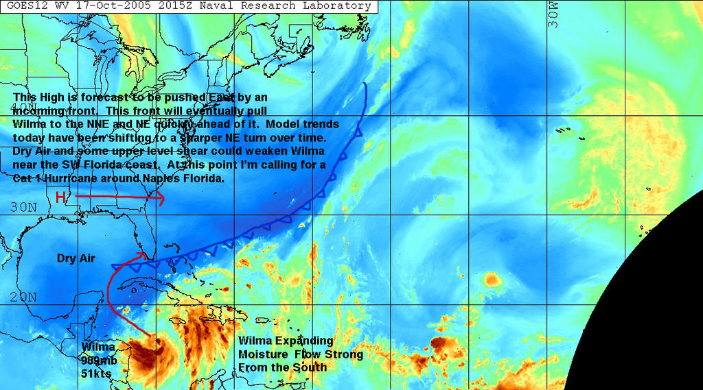
 Wilma currently has about 12 hours of time left to intensify as she crosses over the warm loop current that fed her before she hit Mexico. This is a channel of deep warm water that runs up thru the Yucatan Gap into the Gulf of Mexico. Deep warm water is the fuel all hurricanes need to intensify. Beyond this current there isn't much 88-90 degree water left to support a strong major hurricane. The dry air and shearing from the strong trough coming down from the CONUS is definitely starting to take its toll on the system today. The eyewall was opened on the SSE around 5am this morning allowing dry air to get into the core of the hurricane. It now appears a smaller eyewall is forming inside the large 60nm outer eyewall. This hurricane will need to be watched closely today, but it does appear a weaker Category 1 or 2 hurricane will be making landfall around Marco Island. The models have been shifting south since the 00z run this morning. As a reminder, my forecast track from last Monday put Wilma into Florida as a Category 1 hurricane just south of Naples, Florida.
 One interesting weather phenomenon that I will be watching closely is the potential for Wilma and Alpha to merge off the Atlantic Coast and combine into a Superstorm. We all remember the "Perfect Storm" that sunk the Andrea Gale and created the movie we all watched. This is going to be a very similar situation. This should not pose any threat to land, but Wilma and Alpha are now set to meet and could possibly combine. This will be an amazing site to see on satellite imagery early next week.
SCM


No comments:
Post a Comment