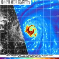
 The hurricane hunters started sending data back to the NHC around 3pm today. Since then they have also sent out a higher altitude NOAA G-IV aircraft and a reserve aircraft to test the high level data around Irene. The data that came back is pretty interesting. The high pressure ridge that is forecast to push Irene potentially West is stronger than the models predicted. This is causing some problems for the current forecast track. I think the NOAA discussion from 11pm sums this up best.
"DROPSONDE DATA FROM THOSE AIRCRAFT INDICATE A SLIGHTLY STRONGER AND MORE WESTWARD EXTENSION OF THE MID-LEVEL RIDGE THAN ANY OF THE MODELS WERE INDICATING FOR 13/00Z...WITH THE UKMET HAVING THE CLOSEST VERIFICATION. THE RIDGE...ALBEIT SOMEWHAT NARROW...EXTENDS FROM NEAR BERMUDA WESTWARD TO NORTH CAROLINA. A SHORTWAVE TROUGH HAS MOVED EASTWARD OFF THE U.S.EAST COAST AND A SHORTWAVE RIDGE OVER THE EASTERN OHIO VALLEY IS MOVING EASTWARD TO TAKE THE PLACE OF THAT TROUGH. IN THE SHORT TERM...THIS SHOULD BUILD OR AT LEAST MAINTAIN THE EXISTING RIDGE TO THE NORTH OF IRENE...WHICH MAY CAUSE A LITTLE MORE WESTWARD MOTION THAN FORECAST FOR THE NEXT 24 HOURS OR SO. AFTER THAT...ALL THE MODELS AGREE THAT IRENE WILL ERODE THE RIDGE AND MOVE SLOWLY NORTHWARD THROUGH THE RIDGE BETWEEN 70-72W LONGITUDE...AND THEN TURN EAST-NORTHEASTWARD BY 72 HOURS. HOWEVER...GIVEN MORE RIDGE SHOWING UP IN THE SYNOPTIC DROPSONDE DATA...THERE MAY BE A WESTWARD SHIFT IN THE 00Z MODEL GUIDANCE. FOR THIS ADVISORY...THOUGH...THE OFFICIAL TRACK WILL REMAIN CLOSE TO THE PREVIOUS FORECAST TRACK.
The 18z model runs did not get this data input before the late night models come out, so this information will not be put into the models until the 8am updates come out. I expect to see some big changes west in the forecast track in the morning. In summary, I think Irene is going to get much closer to the NC/VA coast that the current 300 mile forecast. I guess verified data from the recon flights is proving very useful after all. This is going to get interesting, stay tuned.
SCM
Note - This post is not done by a professional Meteorologist and should not be used for making decisions on safety and protection of property. Always use your local National Weather Service station or the National Hurricane Center for up to date weather information and data.*


No comments:
Post a Comment