 This evening Wilma has been nearly stationary with the latest central pressure measuring 989mb. Concerns this evening have shifted to the growing size of Wilma. What was once a small area of convection SE of the Cayman islands has become a very large area of circulation. Thunderstorms can now be seen rotating from east of Jamaica all the way to south of western Cuba. There is a deep moisture flow coming in from the south that is really feeding the system.
The 18z models have finally come into agreement on a northerly move across western Cuba followed by a NE move into Florida. We will have to watch this trend tomorrow. Wilma could quickly become a large major hurricane in the next 48 hours. Tomorrow the Gulf Stream IV jet is scheduled to fly around the perimeter of Wilma in the upper levels of the atmosphere so better data can be fed into the models. Any uncertainty we can take out of this impending weather situation by helping the models with accurate data is a good thing. Wilma is expected to become a hurricane on Tuesday, probably after the hunter aircraft get in there to verify the satellite data. How big and how strong Wilma is going to get will be the forecasting challenge. Dry air and long term wind shear potential will be Florida's best friend. Expect Florida to go on full alert on Tuesday. With 6 weeks left in the 2005 hurricane season and 10 Category 3 or higher storms in this time period since 1995, we are far from done.
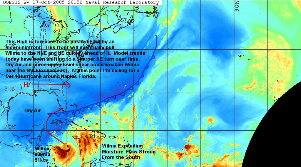
Based on what I am seeing this evening, below is my initial cut at what may happen with Wilma. We may be looking at a storm that becomes a major hurricane in the next 72 hours, then hits south of Naples, Fl as a Category 1 storm.
 SCM
SCM*Note - This post is not done by a professional Meteorologist and should not be used for making decisions on safety and protection of property. Always use your local National Weather Service station or the National Hurricane Center for up to date weather information and data.*


No comments:
Post a Comment