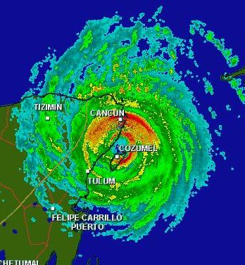
 Cozumel has now been in the eyewall of Wilma for 9 hours, which is just insane. How much longer can they stay in this blender? The convection and cloud tops tonight have started to warm, which is expected with land interaction and continued upwelling of the warm water. Some observations from this evening are that Wilma may be trying to keep some of its eye out over the ocean. This Northward movement tonight means the storm may not weaken as much as forecast. This also means the storm may not stall over the Yucatan as long as the models predicted. The latest model runs are now picking up on this situation by bringing Wilma into Florida as a Category 2 or 3 hurricane. In addition, the latest models have started to shift a bit to the North with each run. Fort Myers may end up being the landfall point. One thing we are sure of is once the storm does start to turn NE, it is going to quickly pick up speed and head towards the Florida coast at 20+mph. This will shorten the timeframe residents will have to prepare and evacuate. Tomorrow should provide some captivating images both from the Aftermath in Mexico and the evacuations in Florida. We'll be here.
SCM


1 comment:
Hey, great site--so easy to read. You've done a great job in interpretation.
http://spaces.msn.com/members/scooterowens
Post a Comment