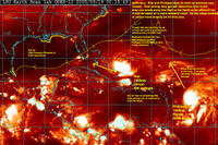
 The forecasted development of 95L and 96L into tropical systems has played out this weekend and now we are dealing with a difficult situation. Rita is close to home and is a potential threat to South Florida and the Gulf of Mexico. Phillippe is a bigger and more impressive looking system that is forecast to move north off the coast.
Rita will pose a threat to South Florida in the next 48 hours. How close Rita comes to South Florida and the Keys will depend on how much influence the high pressure to the north can put on the system and move it on a more WNW direction. The Florida Keys are already under a Hurricane Watch and more watches are expected with the 11pm update by the NHC. The models forecast Rita to become a hurricane and move into the Gulf. The model that did the best with Katrina under a similar setup was the BAMD. Anyone in South Floria needs to watch this storm closely. I believe Rita may hit around Marathon as a strenghtening Category 1 Hurricane, then move into the Gulf. Where it goes from there we will have to wait and see. Most models are gathering around South Texas at this time.
Phillippe is forecast to become a much bigger storm and track more northerly into the Atlantic. The models this year have been pretty bad at forecasting these storms to move due North and just pushing back the high pressure systems. We will see how this plays out with Phillippe. I believe the steering currents may become so weak around Phillippe that it may start to stall in a few days and meander off the East Coast.
Behind Phillippe is 97L.Invest which may eventually be Stan. Here is the model for 97L.
There is no doubt this next week will be a very dangerous situation with so many areas already affected by hurricanes the last 2 years. Decisions being made to do things such as allowing businesses and people back into New Orleans right now are just scary. I hope they have a new plan.
SCM
*Note - This post is not done by a professional Meteorologist and should not be used for making decisions on safety and protection of property. Always use your local National Weather Service station or the National Hurricane Center for up to date weather information and data.*


2 comments:
Good stuff thanks for posting it! Blog-Rage to the extreme! Fast Cash
I will definitely keep an eye on these storms.
Post a Comment