I did miss the Nor'easter here this week in Virginia. I enjoyed a much nicer weather pattern in Huntington Beach California. Here is my Sunset from one evening taken with my Nikon 50mm Lens.
SCM
Friday, September 26, 2008
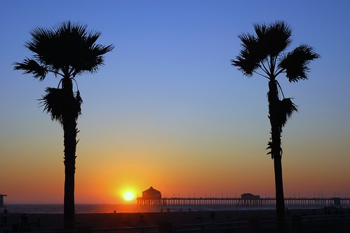
Huntington Beach Pier
Thursday, September 18, 2008

Ike Reality Setting In
 This article has a lot of reality in it when it comes to the search for those stubborn individuals who stayed in Galveston for Ike. I have no idea how high the death toll will go, but I do know it is a lot higher than the 49 the government is reporting today. Very sad situation for the family members searching for those who stayed for this massive storm surge. There is a wave in the mid-caribbean that we might have to keep an eye on if it can develop an LLC.
SCM
Monday, September 15, 2008
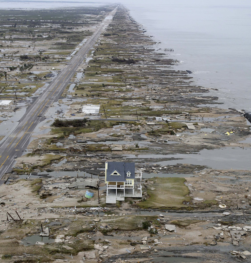
Before and After
Some said that NOAA over warned with the "certain death"comment before Ike. Check these photos of Galveston before and after Ike.
 This is from Dr. Masters' blog.
"According to the New York Times, one Bolivar Peninsula resident was washed all the way across across Galveston Bay to the mainland after the storm surge destroyed his house and threw him into the water. A helicopter picked him up. So far, there are three confirmed deaths on the peninsula, from the town of Port Bolivar. The peninsula had a population of 3,800, of which 500 did not evacuate. As many as 90 people were rescued from the peninsula in the hours leading up to the storm, but at least 400 people remained. Most of these people are as yet unaccounted for. According to news reports, 80% of the buildings on the peninsula were destroyed."
Yes, Ike was Historic. This story will be developing for weeks to come.
SCM
This is from Dr. Masters' blog."According to the New York Times, one Bolivar Peninsula resident was washed all the way across across Galveston Bay to the mainland after the storm surge destroyed his house and threw him into the water. A helicopter picked him up. So far, there are three confirmed deaths on the peninsula, from the town of Port Bolivar. The peninsula had a population of 3,800, of which 500 did not evacuate. As many as 90 people were rescued from the peninsula in the hours leading up to the storm, but at least 400 people remained. Most of these people are as yet unaccounted for. According to news reports, 80% of the buildings on the peninsula were destroyed."
Yes, Ike was Historic. This story will be developing for weeks to come.
SCM
Friday, September 12, 2008
Ike Will Make History
 This is what between 11,000 and 24,000 people decided to try and ride out on Galveston Island tonight. How ironic that people who live on the water have so little respect for it. A 20ft surge will peak around 2am EST tomorrow morning in the dark on the island.
SCM
Thursday, September 11, 2008

Ike - The Next Historic Disaster

I haven't posted about Hurricanes not affecting my area as much as I used to because quite frankly I don't have the time and there are so many other places to read this information that I kind of stopped the blog from being about daily hurricane updates. However today I have to post about what I think is going to happen on the Texas coast in the next 48 hours. When Katrina was approaching New Orleans and Gulfport, you could sense that the Emergency Management officials were dropping the ball big time and people were going to die. So here we are 3 years later and the same thing is happening in the Houston Metro area. Instead of evacuating the Metro area from what could be a historic surge and Category 4 hurricane from hitting the area, they want to keep the roads clear!!!! Shelter in place!!! No shelters will be open!! This is absolutely amazing. The pressure on Ike has been below 950mb for over 12 hours. The storm has been going through a eyewall replacement cycle and once the concentric eyewalls reorganize into one massive eye, we will see the winds catch up to the pressure drop. I have been watching the KHOU stream all morning, and the folks are still waiting and watching to see what they are going to do. I hate to make predictions like this, but in the end this is going to be a historic event. Hardly anyone has left the area, they have less than 48 hours to go and it is too late for people to get out. I hope I'm wrong, but this is going to be a very bad event and people are going to die. You would think we would learn our lessons, but apparently not. I guess evacuations are just too costly and inconvenient. God help those in this storm if it is a Cat 4 getting stronger at landfall, which is possible.
SCM
Monday, September 08, 2008
Severe Threat Tomorrow
Tomorrow I will be in Downtown Washington DC. If the severe threat holds off until after 1pm EST, then I will have the chance to do some photography around the National Monuments with severe weather looming. This is something I have always wanted to do. Lightning strikes or a nice shelf cloud around the Jefferson Memorial or Washington Monument would be nice. I'll have my stuff with me ready to go for more severe weather coverage.
 SCM
SCM
SCMSaturday, September 06, 2008
Tropical Storm Hanna Photographs
See all of my images from Hanna today here. I will be posting my video later this evening. Hanna was a weak tropical storm in the Norfolk, Va area, but she was very picturesque. No rain with an awesome storm line and a little sun light made for a great chance at taking some storm photography. I hope you like them. The storm clouds were right there off the beach and required my ultra wide angle lens to capture them in the frame. They were really screaming by to the North. Here are a couple.

 SCM
SCM
SCM
Hanna Here?
Tropical Storm Hanna made landfall just North of Myrtle Beach at 3:20am this morning. The rain field on the eastern side of the storm is pretty vacant with all the heavy rain to the North and West of the storm, just as NOAA forecasted. The winds here are very light. The core of the storm should move by to our West in about 2-3 hours. I am going to head out shortly to shoot some video, but there really isn't much to see. Pretty tame storm. We are still under a Tornado Watch, so we could get a water spout to spin up. I'll go to Willoughby Spit Beach and see if I can catch anything.
 SCM
SCM
 SCM
SCM
Friday, September 05, 2008
5pm Update: Tornado Watch - Eyewall to Move Over Norfolk, Va
At 5pm the track has shifted back East and the eyewall is now forecast to move directly over Norfolk, Va. At Tornado Watch has also just been issued. It is going to get very interesting here over the next 12 hours.
 SCM
SCM
 SCM
SCM
Hanna's Rains Are Here...
Hanna's first outer storm bands started moving through around 2:30pm EST today. I sure hope we don't get too much rain before the heavy winds get here, but we do need it desperately!
The Live Cam is still up....I will be moving it to a better location to show any surge from the Elizabeth River up towards my house tomorrow morning. I sure am glad Hanna has a firm area of dry air wrapped around its southern and eastern sides. If not we could have a very serious problem up here in Norfolk, Va.

SCM
Thursday, September 04, 2008
Home From Gulfport, Awaiting Hanna
 Here I am in Norfolk, Va awaiting the arrival of Hanna and her Tropical Storm force winds. We are still waiting to see if we get the eastern or western side of the storm as it moves through Southeaster Virginia. The storm track seems to have shifted a bit west this morning and convection definitely looks better than it did 24 hours ago. I still don't see this as being a huge event in my area, but the winds will be brisk and should be fun for a weather enthusiast like myself. Not to mention, today is my birthday and it's always nice to have Mother Nature send me a little gift. The latest track does show us receiving some good winds sometime tomorrow morning/afternoon. There doesn't look to be any shear as the storm moves through my area, so the Tornado risk should be low if we get the eastern side of the storm. However, the friction of the storm cells as they move over land could definitely spin up some weak F1 tornados. I have put up a live cam facing east from the 2nd floor of my house so you can see the tropical moisture and winds move into the area the next 24 hours. I will be providing my usual video and photography coverage of Hanna as it moves closer so keep checking back.
 I just got back from Gulfport, MS where I was visiting a client who was severely impacted by Katrina and just had a brush with Gustav. It was my first trip to the Gulf Coast, so we took I90 along the beach to see some of the Katrina and Gustav damage first hand. It really is amazing to see the damage in person. It is just staggering to think about the size of that storm surge and what it must of been like to live through it. I heard several amazing stories. The trees still have that classic mangled look to them. It's as if a 20 mile wide tornado went through the area and just left nothing in its wake. As I watch Ike making its move towards South Florida or the East Coast, I sure hope we don't see something like this again. It is starting to look more and more likely for whoever is in Ike's path.
Keep checking back as Hanna gets closer. The blog is officially active on storm watch.
SCM
Subscribe to:
Posts (Atom)


