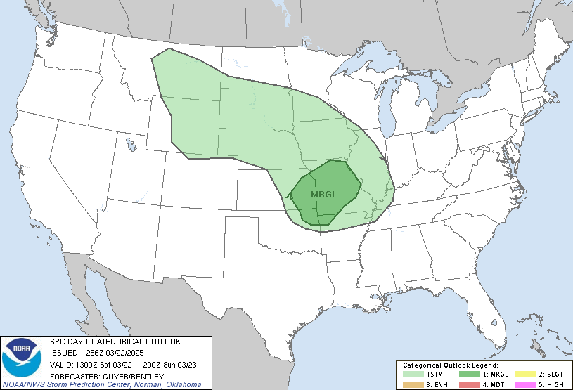
...CAROLINAS TO MID-ATLANTIC REGION... SCATTERED TSTMS ARE EXPECTED TO DEVELOP -- PRIMARILY IN LINEAR MODES -- ALONG/AHEAD OF SFC COLD FRONT ACROSS THIS REGION...BEGINNING EARLY IN PERIOD AND CONTINUING THROUGHOUT MORNING/AFTERNOON PRIOR TO FROPA. MAIN THREAT WILL BE DAMAGING WIND...WITH FCST LOW-LEVEL SHEAR PROFILES INDICATING POTENTIAL FOR EITHER SUPERCELLULAR OR QLCS RELATED TORNADOES IN A FEW LOCALES AS WELL. SVR PROBABILITIES THEREFORE ARE BEING UPGRADED TO CATEGORICAL CRITERIA. RELATIVELY DENSE CONCENTRATION OF CONVECTIVE WIND EVENTS...IN PARTICULAR...IS POSSIBLE WITHIN BROADER AREA OF CATEGORICAL SLGT RISK NOW DRAWN...AND UPGRADE TO PROBABILITIES WITHIN THIS AREA MAY BE NEEDED IN FUTURE OUTLOOKS ONCE MESOSCALE UNCERTAINTIES ARE BETTER RESOLVED. Update: Please check out this inspirational post by Dewdrop! Great job Dew!
SCM


2 comments:
Was watching on radar as the line was heading toward ya and thinking he has to be excited.
Hope that you got what you were looking for and that all is well!
Unfortunately it ended up being a big mess of drizzle and barely noticeable squall line :( Not photo worthy at all.
I tried....
SCM
Post a Comment