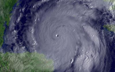
 What a day it has been for us hurricane fanatics. Just to summarize the records we have seen fall today with Hurricane Wilma, here they are:
1. Wilma is the 21st tropical system of the season, tying the record for most storms in one season.
2. Wilma now owns the record for lowest recorded pressure in Atlantic history with 884mb.
3. Wilma went from a Tropical Storm to Category 5 in 18 hours today, dropping 85mb.
4. Wilma maintained an eyewall of 2 nautical miles, extremely small and maybe the smallest ever. (I can't find any data on this fact)
5. Wilma now joins 3 2005 hurricanes in the top 6 of all time for lowest pressure readings.
The only records we hope Wilma doesn't break are the ones for loss of life and property. This evening the winds have dropped down to 160mph with a central pressure of 892mb as Wilma looks to be going through an eyewall replacement cycle. The 18z model runs went a little nuts this afternoon and actually had Wilma not hitting Florida at all, which got everyone a little excited. However, the latest runs have come back in line and South Florida is back in the cross-hairs. One concerning trend with the GFDL model this evening is the long range forecast for Wilma to hit the Northeast coastline. Wilma will likely be a tropical storm at this time, but any deep moisture plume that could hit an already flooded Northeast could be just as dangerous as a hurricane at this point. We will be watching this trend the next several days. I do expect Wilma to weaken some tomorrow as she goes thru the ERC and also comes closer to the east coast of the Yucatan Peninsula. This will affect the western side of the storm as it feels the impact of friction from the land. The long range intensity forecast is still very uncertain. The slower forward speed means some wind shear from the westerlies could impact the system over time, thus weakening the hurricane. I'm sure this will be a big topic for tomorrow, but I don't think we will again see Wilma in the monstrous form that it showed off earlier this morning. If the forecast track remains on Florida overnight, the focus tomorrow will be on evacuations and planning by the local and state officials as we prepare for a weekend impact by Wilma.
Some outstanding High Resolution images of Wilma can be found here, they make great wallpaper for weather enthusiast.
SCM


1 comment:
WOW....what a great report. Definitely the place I go to get the latest information on storms. LY10
Post a Comment