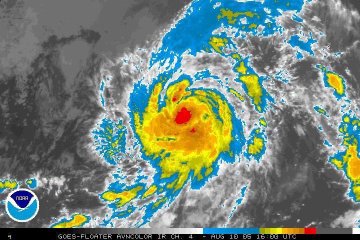
 Irene certainly is gaining quite a bit of strength today. You can clearly see the amount of storm convection near that center that has blown up, along with the outflow to the North and South of the storm. It's kind of puzzling why NOAA isn't scheduling a recon visit with the Hurricane Hunters at this point since the storm has made it to 55 West. I guess they are waiting to send a plane out to visit when it gets closer.
All of the models are starting to come together, including the GFS. Right now the SC/NC border is the landfall point. This will be shifting the next few days. What is most impressive with Irene is how broad of a storm she has become today. Irene was a little girl yesterday, now she is all grown up. I have put together a scenario map below showing what is going on with Irene and the rest of the Atlantic. Joe Bastardi has a great update today on what may be happening with Irene, watch it here.
The ocean in front of Irene is looking more and more favorable for intensification over the next 120 hours. The key is really gonna be how this High Pressure ridge builds in above Irene off the coast. Those of us on the East Coast are used to the scenario of storms starting to turn NW/N/NNE along these systems off the coast. Sometimes the storms will just curve off the coast, sometimes make it inland and do serious damage. Only time will tell at this point, but i'm starting to have some "serious concerns".
 PS: Don't look behind Irene, but the African Wave train for Mid-August is starting to heat up.
SCM
*Note - This post is not done by a professional Meteorologist and should not be used for making decisions on safety and protection of property. Always use your local National Weather Service station or the National Hurricane Center for up to date weather information and data.*


1 comment:
Mike:
Those photos were great! Didn't have a blogger identity so posting under "anon" but it's laureltn. When I can, if you want to, I'll send you some of my florida sunsets with thunderclouds to compare!
Laurel
Post a Comment